
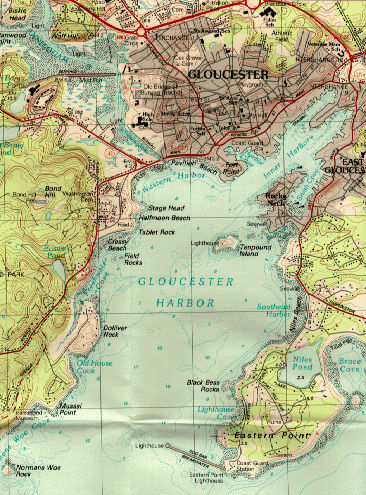
Reference: U.S.G.S. Topographic map/Gloucester Quadrangle.
From the West: Gloucester harbor opens wide and is marked by a breakwater. Green bell (1) off Norman's Woe should be kept to port.
From the East: Pass Brace Cove on Eastern Point. A flashing 5 sec 57-foot horn marks the shore end of the breakwater. The other side of the harbor entrance is marked by a red 4 sec 45-foot horn and a red nun (6) is just west of this horn. Keep this nun to starboard. The green can (7) is for commercial vessels.
From the North: Gloucester harbor is accessible from Ipswich Bay via the Annisquam River. No wake rule is enforced along river. Travel during high tides recommended. Two draw-bridges.
Disclaimer: NOT a nautical chart (for reference only).
| Cape Ann | Gloucester | Essex | Manchester | Rockport | ||||||
>© CACC 1995,1996,1997. Page created by InterMarketing